In the previous post we learned about the methods and devices used for the different stages of the survey (in-shore, shallow waters, deep waters), here we discuss the functionality of the different devices and we see some examples of the information and measurements they have generated during the survey of the IONIAN route.
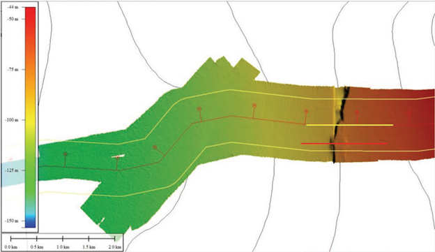
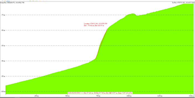
Figure 11 is a bathymetric view produced by the Multi-Beam Echo Sounder (MBES) showing a channel that crosses the survey route close to the Greek coast. Variations in sea-floor relief are depicted with color and contour lines called depth contours or isobaths. Figure 12 shows a profile view along the survey route (yellow line in figure 11) where the channel is very pronounced. Figure 13 is a profile view 350m South of the survey route (red line in figure 11) that avoids the channel and reduces the slope: we should rather modify the cable route and cross the channel close to the red line to avoid this type of irregularity and avoid potential suspensions.
Figure 11 – Preveza shallow water MBES view
Figure 12 - Profile view corresponding to the yellow line on Figure 11
Figure 13 - Profile view corresponding to the red line on figure 11
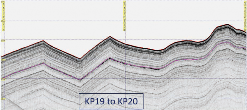
The Sub Bottom Profiler (SBP) provides information on the general geological stratigraphy around the route and is the main source of information for the burial feasibility study in shallow waters. Figure 19 shows typical sediment profiles obtained from the SBP found along the route in the shallow waters near Crotone. Note that the Y axis on these figures represents the distance from the SBP towfish (the sharp peaks on the profile are due to the change of altitude of the towfish, not to actual seabed slopes).
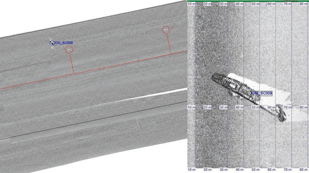
The Side Scan Sonar (SSS) sweeps the seafloor from directly under the towfish to either side, typically to a distance of 100 meters. The image generated is continuously recorded, creating a “picture” of the ocean bottom. Figure 15 shows the image with an uncharted wreck of about 60m length that was found near the Greek coast, located at approximately 320m North of the cable route. Other objects are detected by the SSS such as rocks, pipelines, cables.
Figure 15 – SSS image showing a Ship Wreck 320 meters North of IONIAN’s route. Location (left) and detailed image of the wreck (right)
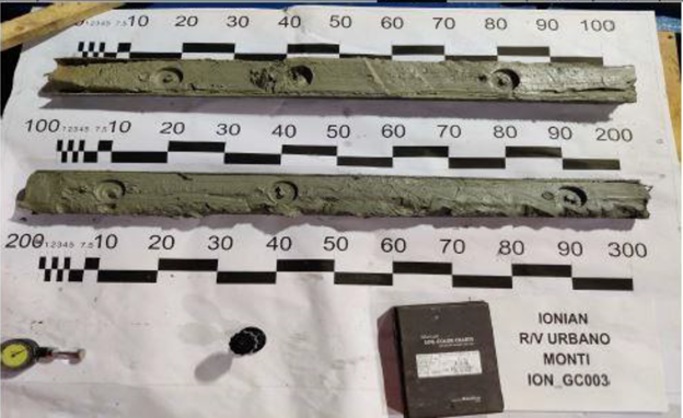
Figure 16 shows a sample of the seabed soil obtained by Gravity coring
Figure 16 - Gravity core samples allow to study the nature of the top layer (3 m) of the seabed
We use cookies on our website to give you the most relevant experience by remembering your preferences and repeat visits. By clicking “Accept All”, you consent to the use of ALL the cookies. However, you may visit "Cookie Settings" to provide a controlled consent.
This website uses cookies to improve your experience while you navigate through the website. Out of these, the cookies that are categorized as necessary are stored on your browser as they are essential for the working of basic functionalities of the website. We also use third-party cookies that help us analyze and understand how you use this website. These cookies will be stored in your browser only with your consent. You also have the option to opt-out of these cookies. But opting out of some of these cookies may affect your browsing experience.
Necessary cookies are absolutely essential for the website to function properly. These cookies ensure basic functionalities and security features of the website, anonymously.
Cookie
Duration
Description
cookielawinfo-checkbox-analytics
11 months
This cookie is set by GDPR Cookie Consent plugin. The cookie is used to store the user consent for the cookies in the category "Analytics".
cookielawinfo-checkbox-functional
11 months
The cookie is set by GDPR cookie consent to record the user consent for the cookies in the category "Functional".
cookielawinfo-checkbox-necessary
11 months
This cookie is set by GDPR Cookie Consent plugin. The cookies is used to store the user consent for the cookies in the category "Necessary".
cookielawinfo-checkbox-others
11 months
This cookie is set by GDPR Cookie Consent plugin. The cookie is used to store the user consent for the cookies in the category "Other.
cookielawinfo-checkbox-performance
11 months
This cookie is set by GDPR Cookie Consent plugin. The cookie is used to store the user consent for the cookies in the category "Performance".
viewed_cookie_policy
11 months
The cookie is set by the GDPR Cookie Consent plugin and is used to store whether or not user has consented to the use of cookies. It does not store any personal data.
Functional cookies help to perform certain functionalities like sharing the content of the website on social media platforms, collect feedbacks, and other third-party features.
Performance cookies are used to understand and analyze the key performance indexes of the website which helps in delivering a better user experience for the visitors.
Analytical cookies are used to understand how visitors interact with the website. These cookies help provide information on metrics the number of visitors, bounce rate, traffic source, etc.
Advertisement cookies are used to provide visitors with relevant ads and marketing campaigns. These cookies track visitors across websites and collect information to provide customized ads.