In this second post of the IONIAN system series, we discuss the reasons for the choice of the submarine route.
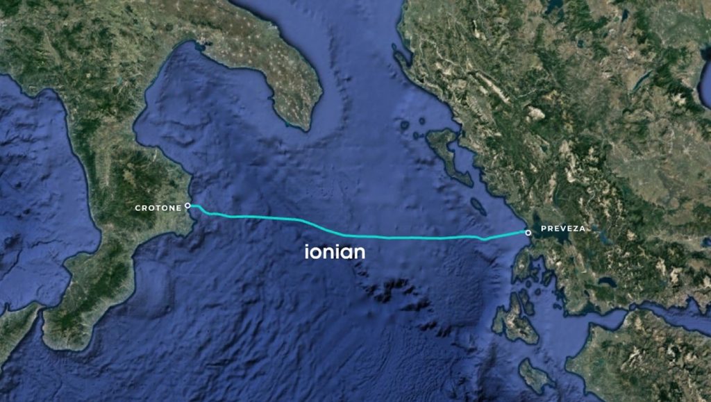
IONIAN is a point-to-point submarine cable landing near the cities of Crotone in Italy and Preveza in Greece. It crosses the Ionian Sea in an East-West (almost) straight line. The designed submarine route has a total length of c. 317 km.
IONIAN uses low attenuation fibers, so no amplifiers are required, and still allowing a very large capacity (> 15 Tbps) per fiber pair with current transmission technology.
Looking at the Route map (fig. 1), it is obvious that from a geographical point of view, there are options on the North of this route to reduce the cable stretch. This would shorten the marine route although, if the end goal is to connect Athens, it would be partially offset by a longer terrestrial route.
The reason of the choice of IONIAN’s route is that it has been engineered to maximize the reliability of the cable, while keeping the marine stretch short enough to avoid the need of amplifiers with low attenuation fibers. Given that the major causes of submarine cable
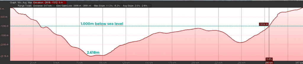
cuts are due to human activity, such as fishing and anchoring, the best way to minimize such risks is by laying the cable in deep waters. Additionally, not having submerged active elements (amplifiers) also increases the reliability and durability of the system. The picture below is the elevation profile of the IONIAN cable route. As can be appreciated, most (78%) of the cable will be deployed below the 1.000m water depth limit.
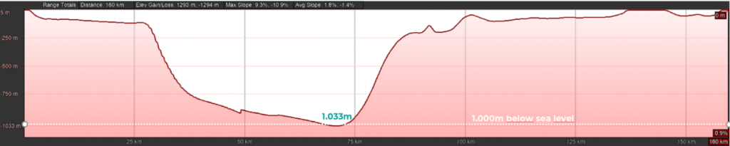
The Ionian Sea is characterized by its deep waters (the deepest point in the Mediterranean, Calypso Deep is in the Ionian Sea). As we move North, towards the Adriatic Sea, the water depth decreases. As can be seen below, a hypothetical route following the shortest path between the Italian peninsula and the Northernmost part of Greece would have most of the cable (72%) with a water depth of less than 250 meters.
1. Maximize reliability by avoiding cut hazards >> deep waters
2. Avoid submerged active elements to extend the lifetime >> unrepeated cable
Finally, the choice of the landing points is a very important decision, since the availability of appropriate infrastructure, a reliable supply of energy and a safe location for the cable landing stations are all critical for the system to operate in good conditions. But that is a different story…
Previous post:
The IONIAN system – Why the IONIAN System?
| Cookie | Duration | Description |
|---|---|---|
| cookielawinfo-checkbox-analytics | 11 months | This cookie is set by GDPR Cookie Consent plugin. The cookie is used to store the user consent for the cookies in the category "Analytics". |
| cookielawinfo-checkbox-functional | 11 months | The cookie is set by GDPR cookie consent to record the user consent for the cookies in the category "Functional". |
| cookielawinfo-checkbox-necessary | 11 months | This cookie is set by GDPR Cookie Consent plugin. The cookies is used to store the user consent for the cookies in the category "Necessary". |
| cookielawinfo-checkbox-others | 11 months | This cookie is set by GDPR Cookie Consent plugin. The cookie is used to store the user consent for the cookies in the category "Other. |
| cookielawinfo-checkbox-performance | 11 months | This cookie is set by GDPR Cookie Consent plugin. The cookie is used to store the user consent for the cookies in the category "Performance". |
| viewed_cookie_policy | 11 months | The cookie is set by the GDPR Cookie Consent plugin and is used to store whether or not user has consented to the use of cookies. It does not store any personal data. |